Cadastre ·
Exceso de cabida: when Cadastre and Registry differ
A rural plot in la Costera measured more than registered. How we justified the excess of area with a survey, historical photos, IVGA and ICUC before its sale.

There is an excess of area (exceso de cabida) when the real property measures more than the Land Registry (Registro de la Propiedad) says. It is very common on rural plots in the Valencia region (Comunitat Valenciana), described decades ago in hanegadas (a traditional Valencian land measure) and never measured. The problem appears on the day you want to sell: the buyer, the bank or the notary need what is registered and what is on the ground to be the same. This article explains how we resolved it on a property in la Costera.
What is an excess or a shortfall of area?
The cabida is the area of the property. There is an excess when the real area is larger than the registered one and a shortfall when it is smaller. It does not mean anyone has done anything wrong: the usual story is that the property was described by eye, with approximate measurements, and nobody ever checked.
What does matter is how it is corrected. The Land Registry does not simply accept extra metres: you have to show that the land has always belonged to the property and that it has not been taken from a neighbour, a track or a ravine (barranco). That proof is technical, and that is where the land surveyor comes in.
Why do the Cadastre and the Land Registry not match?
Because they were born separately. The Land Registry records rights based on written descriptions. The Cadastre (Catastro, Spain’s land and property register for tax purposes) draws parcels for tax. For decades they did not talk to each other, and on many properties the cadastral area, the registered area and the real area are three different numbers.
Since 2015 the law has sought to coordinate them: the registered property should have a graphic representation and it should match the Cadastre’s. To get there, you have to measure.
The case: a rural property in la Costera before its sale
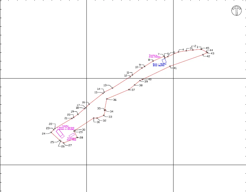
The owners of a long, narrow rural property, with a storeroom and some ancillary buildings, were about to sell it. The property had an excess of area: it measured more than was registered.
What we measured
We carried out a full topographic survey of the perimeter and the buildings. Every change of direction in the boundary was recorded as a numbered vertex with coordinates.
What we analysed
- The title deed (escritura), with its area and its described boundaries.
- The evolution over space and time: orthophotos and flights from different periods and the historical cadastre, to see whether the outline of the property had always been the same.
- The topographic survey, as the current physical reality.
How we processed it
We georeferenced all the information and overlaid it in the same coordinate system. The question was whether the outline we measured today is the same one shown by the flights and the cadastre of other periods. That comparison is what makes it possible to justify an excess of area: it shows where the land comes from and that it has not been taken from an adjoining owner.
What we delivered
- A technical report justifying the excess of area requested.
- The corresponding cadastral documentation: the alternative graphic validation report (IVGA, Informe de Validación Gráfica Alternativa), which checks that the new outline fits the parcel map, and the cadastral building location report (ICUC, Informe Catastral de Ubicación de Construcciones), which places the buildings within the property.
How it ended
The property was coordinated in the Cadastre and the Land Registry with its real area. The sale went ahead on a property described in the same way in both places and on the ground, which is what the buyer needs in order to sign with peace of mind.
What steps are needed to register an excess of area?
- Measure the property with a georeferenced survey.
- Justify the excess with a technical report showing that the outline is old and stable.
- Generate the GML file (the georeferenced parcel format the Cadastre and the Land Registry require) of the property and obtain the IVGA from the Cadastre’s online office (Sede Electrónica). If there are buildings, the ICUC as well.
- Process it through the notary or the Land Registry, which decides on the procedure and notifies the adjoining owners.
If the IVGA result is not positive or a neighbour objects, the file becomes more complicated. That is why step 2 needs to be done well: a solid report avoids most of the problems.
In cadastral discrepancies we explain other common mismatches between the Cadastre and the Land Registry, and in the case of a plot with a planter we saw the opposite: a measurement that ended up confirming the title deed.
Frequently asked questions
Is a land surveyor’s plan enough to register the extra metres?
No. The plan and the report are the technical basis, but the registration is decided by the land registrar following the procedure of the Spanish Mortgage Act (Ley Hipotecaria), which may include notifying the neighbours. No plan on its own proves ownership.
And if, instead of extra land, there is less?
The path is the same: measure, justify and coordinate. A shortfall of area is corrected in the same way, and it is best done before selling so that nobody pays for metres that do not exist.
When is it best to resolve it, before or after selling?
Before. With the property coordinated, the sale is simpler for everyone: the buyer knows what they are buying, and the notary and the bank have the same description as the land.
If your property has an excess or a shortfall of area, we prepare the documentation for the Cadastre and the Land Registry based on a measurement of the plot and its boundaries.
Tags catastroregistro de la propiedadactualizacion catastrallevantamiento topografico
Written by Vicent Doménech, geodesy and cartography engineer, chartered surveyor no. 8948.

