Cadastre ·
Certificate of age for a building: aerial photo proof
How to prove how long a house, a pool or an outbuilding has existed in Spain: historical aerial surveys, the old Cadastre and spatio-temporal analysis.
Proving the age of a building means showing, with evidence, how long it has existed. You need it to register with the Land Registry (Registro de la Propiedad) a house, a pool or an outbuilding that was never declared, to record it in the Cadastre (Catastro, Spain’s land and property register for tax purposes) with its real date, or to settle an inheritance or a sale. The strongest evidence is usually in the sky: the photographic flights that have been flown over Spain since the middle of the twentieth century. Analysing them methodically is what we call spatio-temporal analysis.
Why do you need to prove the age of a building?
Because many buildings exist on the ground but not on paper. A small field hut from the 1960s, an extension from the 1980s, a pool built without being declared. As long as nobody sells or inherits, nobody asks. When the notary gets involved, they do.
Spain’s national land legislation allows buildings to be registered with the Land Registry when measures to restore planning legality can no longer be taken against them, because the time limits set by the regulations have passed. To do this, you have to prove that the work was finished by a certain date. One of the routes provided for is a certificate from a competent technician. Which time limits apply in each case depends on the type of land and the planning regulations; your lawyer, the notary or the town council will confirm that.
The same study can be used before the Cadastre, when a building has to be recorded with its real date or when the date on record needs correcting.
What is spatio-temporal analysis?
It means comparing the same place on different dates to find out when it changed. In our case, when a building appears. It is done with:
- Historical flights from the Instituto Geográfico Nacional (Spain’s National Geographic Institute), from the so-called American flight of the mid-1950s to the current orthophotos of the PNOA (the National Aerial Orthophotography Plan).
- Orthophotos and flights from the Institut Cartogràfic Valencià.
- Old cadastral mapping, such as the topographic parcel cadastre (catastro topográfico parcelario), and the successive versions of the Cadastre.
- The current survey of the building, measured in official coordinates.
The key is to georeference every image in the same system as the survey. A scanned aerial photo from 60 years ago does not fit a present-day plan without that step. Once they fit, the current building is digitised over each flight and we check whether it was already there.
What it looks like in practice
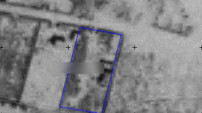
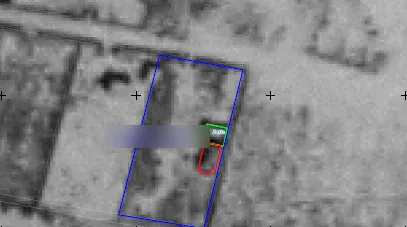
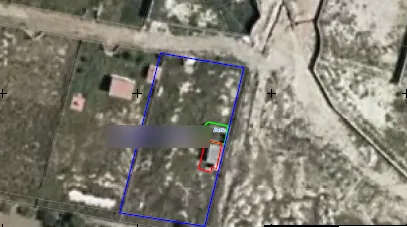
The sequence is repeated with every flight available. The result is an interval: the building does not appear in a flight from one date and does appear in the next. The more flights there are, the narrower the interval.
What does the report include?
- The survey of the building in official coordinates, with its floor area.
- Each flight used, with its date, its source and the building overlaid.
- The historical Cadastre and how it has changed, if it adds information.
- The conclusion: the date or the range of dates by which the building already existed, and with what degree of certainty.
- If needed, the GML file of the building (the georeferenced parcel format the Cadastre and the Land Registry require) for the cadastral building location report (ICUC), which places the building within the plot. We explain the ICUC and the alternative graphic validation report (IVGA, Informe de Validación Gráfica Alternativa) in IVGA and ICUC.
What are its limits?
It is worth knowing them before you start:
- The resolution of old flights. A house can be seen; a small hut under a carob tree, perhaps not.
- How often flights were made. Years can pass between some historical flights; the date that is proved is an interval, not a day.
- Shadows and vegetation, which can hide part of a building.
- Alterations: the analysis says when a footprint appears, not whether the building has been altered inside.
That is why the report distinguishes between what can be seen clearly and what is probable, and does not claim more than the images show. And that is why we always start by measuring the building: without its footprint in coordinates, there is nothing precise to overlay on the flights.
Frequently asked questions
Is the year shown by the Cadastre enough?
Sometimes the Cadastre already records a construction date, and a cadastral certificate that matches the title deed (escritura) is another possible route. But if the cadastral date is wrong or the building has not been recorded, other evidence is needed, and the analysis of flights is the most objective.
Can I use old family photos?
They help as supporting evidence, especially if the building can be seen along with something that allows them to be dated. But they do not have the objectivity of an official flight with a known date.
Does it work for buildings on rural land?
The technical analysis is the same on any type of land. What changes is the planning treatment, which depends on the land classification and the applicable regulations.
If you need to prove the age of a building, we prepare the study and the documentation for the Cadastre and the Land Registry with our cartographic analysis.
Tags catastroregistro de la propiedadgeorreferenciacionanalisis
Written by Vicent Doménech, geodesy and cartography engineer, chartered surveyor no. 8948.

